![]()
|  |

Project Work Locations
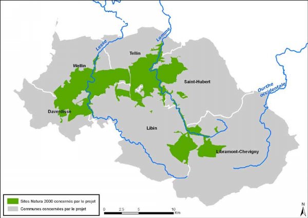
The Project will proceed on three Natura 2000 sites, covering an area of 10,197 hectares within the two large orohydrographical basins of the Lomme and the Lesse. The municipalities concerned are Libramont-Chevigny (1,143 hectares), Libin (2,684 hectares), Daverdisse (1,575 hectares), Wellin (1,741 hectares), Tellin (1,631 hectares) and Saint-Hubert (1,750 hectares).
This work perimeter includes the Central Ardennes' high plateaus (Plateau de Recogne, de Saint-Hubert and de Tellin). Recently, large-scale restoration activity has been conducted, through other LIFE projects, on the main Ardennes plateaus: Plateau des Tailles, de la Croix-Scaille, de Saint-Hubert and des Hautes-Fagnes. In this context, the plateaus of the Lomme basin constituted a link for constituting an ecological network of boggy and hydromorphic habitats (typical natural habitats of the Ardennes high plateaus).
The LIFE-Lomme Project will complete this network of habitats, for example by converting spruce plantations that are growing on soaked ground into peat bogs or wet moors. Beside the high plateaus, the LIFE-Lomme Project will also seek to restore certain valley floors. In terms of ecological network, the waterways constitute an essential component! They allow on the one hand the development of species contained within those environments, but also, on the other, because of the intrinsic interconnections of the waterways and the alluvial environments, they can ensure the displacement of species between different high plateaus. Finally, the beech groves on the slopes bordering the brooks have been added to these wet environments.
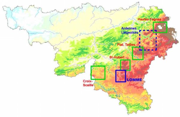
The LIFE-Lomme Project's General Location
|
The Lomme basin (framed in blue), a missing link for the boggy habitats of the Ardennes high plateaus. This map locates the perimeters of action of four other LIFE projects (framed in green), currently underway or finalised, and seeking the restoration of natural habitats on boggy grounds. |
|
Which owners are concerned?
Most of the candidate restoration areas are owned by public entities: the Municipalities (54%), the Province (9%) or the Region (6%); the remaining plots of land (31%) belong to private owners.
The breakdown of the owners varies according to the type of habitat concerned : the high plateaus are mainly public property whereas the valley floors often consist of numerous private plots of land.
Municipalities concerned by the project
|
Three Natura 2000 sites
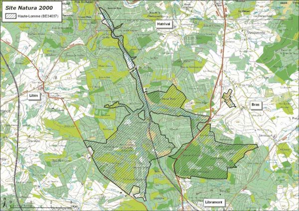
The project is envisaged on three Natura 2000 sites located at the heads of the Lesse and the Lomme basins. The main economic activities in the three Natura 2000 sites concerned are forestry and hunting: 95% of the sites is covered with forests. 11.4% of the three Natura 2000 sites (1,150 hectares) are occupied by ground on which forestry is made very difficult: boggy, hydromorphic and alluvial grounds. Among those, approximately 500 hectares are currently occupied by coniferous tree plantations or have deteriorated in various ways and are therefore candidates for restoration actions. A part of the site includes the state nature reserves of Troufferies de Libin (66 hectares), Fange de Tailsus (2 hectares) and Haie à Chenot (5 hectares). In this Natura 2000 site, the preferential work area includes the Lomme at Pont-à-Libin (SGIB 957) , Troufferies de Libin (SGIB 65) , Fange de Tailsus (SGIB 597) , Fange de Bubu (SGIB 595) , To urbière des Anomalies (SGIB 1694) and Grande Fange (SGIB 1695) .
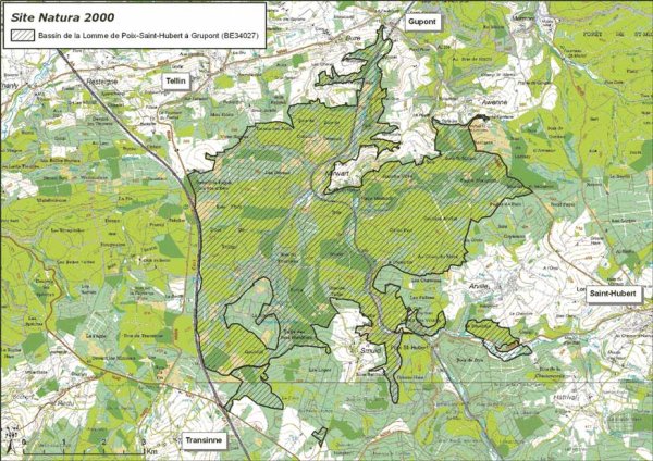
A part of the site includes the state nature reserves of Pré des Forges (24.3 hectares). In this Natura 2000 site, the preferential work area includes the floors of the valleys of the Lomme with in particular the Grand Han area, from Pré des Forges (SGIB 75) and the valley of the Parfond Ri (SGIB 1778) , the valley of Pierre au Charme et du Marsaut (SGIB 1054) , until their sources which harbour major areas such as Fange Mariette (SGIB 592) . Towards Saint-Hubert, the site also includes the wet meadows of Val de Poix (SGIB 1056) .
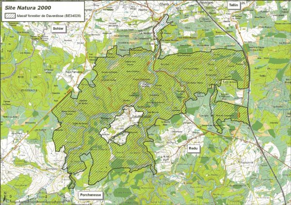
In this Natura 2000 site, the preferential work area includes the floors of the valleys of the Lesse downstream from Daverdisse and on the tributaries of the Brook of Wéry, the Brook of Glands and of Passe-Brebis.
|